Community Corner
Planters, Beware: There Could be a Freeze This Weekend
The National Weather Service has issued a hazardous weather outlook for the possibility of a frost or freeze on Saturday night.
Those Lakeville residents wanting to work out their green thumbs may want to wait a few more days before planting.
The National Weather Service has issued a hazardous weather outlook for the potential of a widespread frost this weekend. There is a chance temperatures could get cold enough for a freeze.
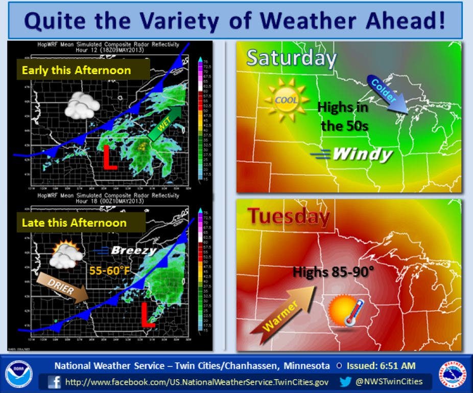
The weather service says temperatures could fall as low as the upper 20s or lower 30s in the Twin Cities metro area on Saturday night.
Find out what's happening in Lakevillewith free, real-time updates from Patch.
Here is the text of the hazardous weather outlook:
THIS HAZARDOUS WEATHER OUTLOOK IS FOR PORTIONS OF CENTRAL AND SOUTHERN MINNESOTA... AND WEST CENTRAL WISCONSIN.
Find out what's happening in Lakevillewith free, real-time updates from Patch.
.DAY ONE...THIS AFTERNOON AND TONIGHT
A FEW NON-SEVERE THUNDERSTORMS WILL OCCUR ACROSS THE OUTLOOK AREA THIS AFTERNOON.
.DAYS TWO THROUGH SEVEN...FRIDAY THROUGH WEDNESDAY
THE PASSAGE OF A POTENT COLD FRONT FRIDAY NIGHT WILL RESULT IN STRONG NORTHWEST WINDS ON SATURDAY WITH WIND GUSTS BETWEEN 30 AND 40 MPH. THESE WINDS WILL RESULT IN CHOPPY CONDITIONS ON AREA LAKES SATURDAY.
A WIDESPREAD FROST AND/OR FREEZE IS LIKELY SATURDAY NIGHT ACROSS THE ENTIRE OUTLOOK AREA AS TEMPERATURES FALL INTO THE UPPER 20S OR LOWER 30S. FROST IS POSSIBLE AGAIN ACROSS WESTERN WISCONSIN SUNDAY NIGHT.
By the way, the average high temperature in the Twin Cities for May 9 is 67. The average low is 47.
Here is the weather service’s forecast for the next few days:
TONIGHT: Isolated showers between 7pm and 8pm. Mostly cloudy, with a low around 41. North northeast wind 10 to 15 mph. Chance of precipitation is 20%.
FRIDAY: Mostly sunny, with a high near 64. North northeast wind 5 to 10 mph becoming northwest in the afternoon.
FRIDAY NIGHT: A 40 percent chance of showers. Mostly cloudy, with a low around 42. Breezy, with a west wind 5 to 10 mph becoming north northwest 15 to 20 mph after midnight. Winds could gust as high as 30 mph.
SATURDAY: Sunny, with a high near 51. Breezy, with a northwest wind 20 to 25 mph, with gusts as high as 35 mph.
SATURDAY NIGHT: Areas of frost after 4am. Otherwise, mostly clear, with a low around 30. Blustery, with a northwest wind 15 to 20 mph decreasing to 5 to 10 mph after midnight. Winds could gust as high as 30 mph.
SUNDAY: Areas of frost before 8am. Otherwise, sunny, with a high near 57. Northwest wind around 10 mph.
SUNDAY NIGHT: Mostly clear, with a low around 39. Northwest wind 5 to 10 mph becoming south southwest after midnight.
Looking forward to next week, warmer weather appears on the way.
Click here for an updated forecast for Lakeville.
