Community Corner
UPDATE: Dakota County Under Severe Thunderstorm Watch Until 2 a.m. Wednesday
The northern part of the county—not including Lakeville—was under a severe thunderstorm warning until 8:45 p.m. Tuesday.
UPDATE TUESDAY 9 P.M.: The National Weather Service has issued a severe thunderstorm watch for Dakota County until 2 a.m. Wednesday.
At 7:35 p.m. Tuesday, the watch was issued for the following counties: ANOKA, BENTON, CARVER, CHISAGO, DAKOTA, GOODHUE, HENNEPIN, ISANTI, KANABEC, KANDIYOHI, LE SUEUR, MCLEOD, MEEKER, MILLE LACS, PINE, RAMSEY, RENVILLE, RICE, SCOTT, SHERBURNE, SIBLEY, WABASHA, WASHINGTON, WINONA and WRIGHT.
The northern part of Dakota County—including the cities of Burnsville, Apple Valley, Rosemount and Eagan—were put under a severe thunderstorm warning at 7:49 p.m. Tennis ball-size hail and high winds were listed as the hazards of the storm.
Find out what's happening in Lakevillewith free, real-time updates from Patch.
Patch will update this story if necessary.
__________________________
Find out what's happening in Lakevillewith free, real-time updates from Patch.
UPDATE 2:40 P.M. TUESDAY—Lakeville and Dakota County are included in a tornado watch that's in effect through 9 p.m. Tuesday.
_____________________________
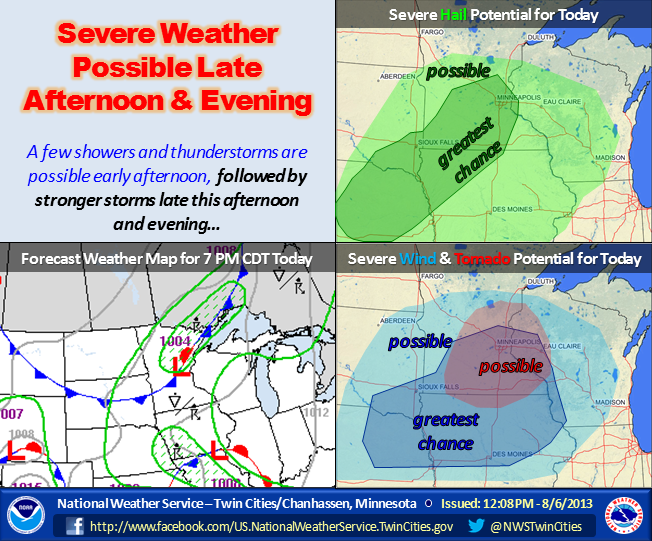
ORIGINAL STORY: The weather could be stormy for Tuesday evening’s Night to Unite block parties.
The National Weather Service has issued a hazardous weather outlook for central and southern Minnesota, including Lakeville.
There is a “slight risk” severe weather, namely severe thunderstorms and a tornado or two, on Tuesday afternoon and night.
Here is the text of the hazardous weather outlook, issued at 3:22 a.m. Tuesday:
.DAY ONE...TODAY AND TONIGHT
THERE IS A SLIGHT RISK OF SEVERE THUNDERSTORMS THIS AFTERNOON AND EVENING. HAIL TO GOLF-BALL SIZE AND WIND GUSTS TO 60 MPH WILL BE THE PRIMARY HAZARDS. CONDITIONS MAY BECOME FAVORABLE FOR A FEW TORNADOES SOUTH AND EAST OF A LINE FROM REDWOOD FALLS THROUGH THE NORTHERN TWIN CITIES TO RICE LAKE FOR A BRIEF TIME DURING THE LATE AFTERNOON AND EARLY EVENING HOURS. STORMS ARE EXPECTED TO IMPACT AREAS WEST OF I-35 BETWEEN 2 AND 6 PM... AND LOCATIONS TO THE EAST BETWEEN 6 PM AND MIDNIGHT. A FEW SHOWERS AND THUNDERSTORMS COULD OCCUR OVER THE OUTLOOK AREA THIS MORNING... BUT THEY ARE NOT EXPECTED TO BE SEVERE.
.DAYS TWO THROUGH SEVEN...WEDNESDAY THROUGH MONDAY
THUNDERSTORMS WILL BE POSSIBLE AGAIN THURSDAY AFTERNOON...
THURSDAY NIGHT... AND SUNDAY INTO EARLY MONDAY... BUT THEY ARE NOT EXPECTED TO BE SEVERE.
FORECAST FOR THE COMING DAYS
Here is a look at the weather forecast for the coming days:
• TUESDAY—Partly cloudy. Areas of dense fog in the morning. A 50 percent chance of showers and thunderstorms in the afternoon. Highs around 80. Southwest winds 5 to 10 mph.
• TUESDAY NIGHT—Showers and thunderstorms likely in the evening...then partly cloudy with a slight chance of showers and thunderstorms after midnight. Lows in the upper 50s. Northwest winds 5 to 10 mph. Chance of rain 70 percent.
• WEDNESDAY—Mostly sunny. Highs in the lower 70s. North winds 10 to 15 mph.
• WEDNESDAY NIGHT—Mostly clear. Lows in the lower 50s. North winds around 5 mph shifting to the south after midnight.
• THURSDAY—Partly cloudy. A 20 percent chance of showers and thunderstorms in the afternoon. Highs in the mid 70s. Southwest winds 5 to 10 mph.
• THURSDAY NIGHT—Partly cloudy with a 30 percent chance of showers and thunderstorms. Lows in the upper 50s.
• FRIDAY—Partly cloudy in the morning...then becoming mostly sunny. Highs in the mid 70s.
• FRIDAY NIGHT—Mostly clear. Lows in the mid 50s.
• SATURDAY—Mostly sunny in the morning...then becoming partly cloudy. Highs in the mid 70s.

