Community Corner
Cool Enough for You?
A local meteorologist says a late start to summer-like weather and recent chilly temperatures have taken a bite out of our summer calendar.
A six-week summer? That’s what one meteorologist suggests we might be having this year.
In his Updraft blog published on Tuesday, Minnesota Public Radio’s chief meteorologist, Paul Hutter, says the the late arrival of typical summer weather and the recent string of cooler-than-usual temperatures has taken a bite of our summer calendars.
Here is a portion of his blog:
Find out what's happening in Lakevillewith free, real-time updates from Patch.
Realistically, “summer” in Minnesota began on June 16th this year when the mercury hit 86 degrees n the metro. It may have “ended” when we hit 83 degrees on July 25. That’s the last day with an 80+ degree in the metro high before we plunged into our current state of weather affairs — a string of days in the 70s and even October-like 60s.
6 weeks of summer in Minnesota this year?
Find out what's happening in Lakevillewith free, real-time updates from Patch.
That would be hard to take for even the most hardy Minnesotans after the non spring of 2013. I’m not saying we’re done with 80s this year. But they look unlikely for the next 10 days or so. The maps do look potentially warmer by mid-August, and another string of 80s, even a 90 degree day or two is not out of the question. The State Fair still brings us a shot of 90 degree heat, right?
Monday’s high temperature reached 79 in Minneapolis . That’s still four degrees below normal.
COOLER-THAN-AVERAGE FORECAST
The National Weather Service is forecasting below-average temperatures through at least the early part of next week. Highs are predicted to be in the mid 70s and lows are expected to be in the 50s.
That compares to the normal average highs in the low to mid 80s and lows in the mid 60s.
Here is the forecast for the coming days:
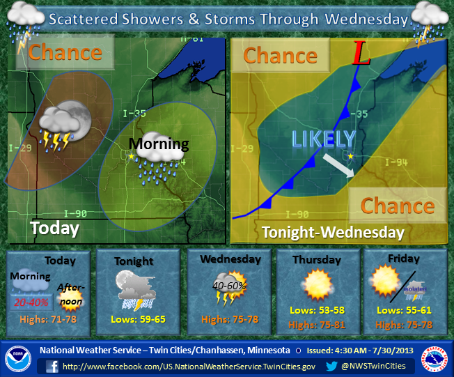
• TUESDAY AFTERNOON—Mostly cloudy, with a high near 72. South southeast wind around 5 mph.
• TUESDAY NIGHT—A 20 percent chance of showers and thunderstorms after 3am. Mostly cloudy, with a low around 62. South wind around 5 mph.
• WEDNESDAY—Showers and thunderstorms likely, mainly before 10am. Mostly cloudy, with a high near 77. Southwest wind 5 to 10 mph becoming northwest in the afternoon. Chance of precipitation is 60%. New rainfall amounts between a tenth and quarter of an inch, except higher amounts possible in thunderstorms.
• WEDNESDAY NIGHT—Mostly clear, with a low around 57. West wind 5 to 10 mph.
• THURSDAY—Sunny, with a high near 78. West northwest wind 5 to 15 mph.
• THURSDAY NIGHT—Partly cloudy, with a low around 58. West northwest wind 5 to 10 mph becoming southwest after midnight.
• FRIDAY—Mostly sunny, with a high near 77. North northwest wind around 5 mph.
• FRIDAY NIGHT—Mostly clear, with a low around 56. North northwest wind around 5 mph.
• SATURDAY—Sunny, with a high near 76. North wind around 5 mph.
• SATURDAY NIGHT—Mostly clear, with a low around 56. North wind around 5 mph becoming calm after midnight.
• SUNDAY—A 30 percent chance of showers and thunderstorms. Mostly sunny, with a high near 76. Calm wind becoming east around 5 mph.
• SUNDAY NIGHT—A 40 percent chance of showers and thunderstorms. Mostly cloudy, with a low around 61. East southeast wind around 5 mph.
• MONDAY—A 40 percent chance of showers and thunderstorms. Mostly cloudy, with a high near 75. Southeast wind around 5 mph becoming calm.
HAZARDOUS WEATHER OUTLOOK
The weather service has issued a hazardous weather outlook for severe weather on Wednesday.
Here is the text of the outlook:
THIS HAZARDOUS WEATHER OUTLOOK IS FOR PORTIONS OF CENTRAL AND
SOUTHERN MINNESOTA... AND WEST CENTRAL WISCONSIN.
.DAY ONE...THIS AFTERNOON AND TONIGHT
SCATTERED THUNDERSTORMS ARE POSSIBLE ACROSS WESTERN MINNESOTA THIS EVENING...AND WILL MOVE EASTWARD DURING THE OVERNIGHT HOURS. SEVERE WEATHER IS NOT EXPECTED.
.DAYS TWO THROUGH SEVEN...WEDNESDAY THROUGH MONDAY THUNDERSTORMS WILL BE POSSIBLE WEDNESDAY. SOME STORMS WILL BE CAPABLE OF PRODUCING STRONG WINDS AND HAIL.
THE NEXT BEST CHANCE OF THUNDERSTORMS WILL OCCUR EARLY NEXT WEEK.

